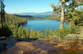
Cascade Falls Hiking Trail

Difficulty: Moderate
Elevation: 6800′ / 6910′
Mileage (one way): 1.3-mile out-and-back
Directions to Trailhead : Take Highway 89 north from South Lake Tahoe approximately 8 miles to the Bayview Campground across from Emerald Bay, Inspiration Point. You will find parking is located at the far end of the campground. In the summer arrive before 9 am if you want to park near the trailhead. There is additional parking along the entrance to Bayview Campground where you will then walk through the campground to the start of the trailhead.
Trail : Look for the trailhead sign at the far end of the parking area. There is some limited parking so in the summer months you might want to get an early start to guarantee a spot. The hike is moderate and could be considered easy for some depending on your fitness and level of ability. At a good pace you can make it to the falls in roughly 40 minutes. Although there is not a lot of elevation change there are some spots along the trail as you navigate some larger rocks/small boulders. The trail is well maintained so these areas tend to be easy to navigate through when you take your time.
The Cascade Falls hiking trail is a great option if you’re looking for a scenic hike without committing to a full day on the trail. It’s the perfect spot to bring a packed lunch and unwind by the numerous stream shoots that then flow into Cascade Falls. Take in the breathtaking views and enjoy a relaxing break by the falls. The impressive large rock outcroppings and trees growing from small cracks add to the charm of the area. It’s a manageable hike that kids would love, with a picturesque creek and lively falls at the end. The creek runs vigorously in late spring and early summer, but slows down significantly in the fall.
Attractions and Considerations : Spectacular views of the 200 foot high falls and Cascade Lake.
Useful Map Information :USDA Forest Service map: Lake Tahoe Basin Mgnt. Unit: R.17 E. T. 13 N.
Map / Directions
Parking at Bayview Campground


